

Hanover & Tarner Liveable Neighbourhood – Boundary Roads engagement summary
Two online and two in-person engagement events took place on Feb 1st/2nd 2023, aiming to share the most recent design proposals for Elm Grove (up to its junction with Queens Park Road), Queens Park Road and Egremont Place. They were attended by residents from the Hanover, Queens Park and Tarner areas who had been invited via a postcard delivery to the named streets and local social media
The summary below is of the key points and issues raised in relation to these roads. The summary is restricted just to those roads and the response to the proposals considered. Although points, comments and questions were raised around the process and delivery of the wider Low Traffic Neighbourhood scheme this subject was not the main issue of the meeting, and attendees wanted to underline that comments made were just a reflection of the boundary roads and not a comment for or against the Liveable Neighbourhood scheme as a whole
The events started with a presentation from Ben Stride – council Highway Projects engineer – who talked us through the interventions proposed for the boundary roads and led a Q&A for the whole group. Following this, participants split into smaller groups to discuss the proposals and make any suggestions for change or improvement.
All of the comments and suggestions made were recorded and will be used to inform development of the scheme.
One – Elm Grove from Lewes Road to the Queens Park Road junction
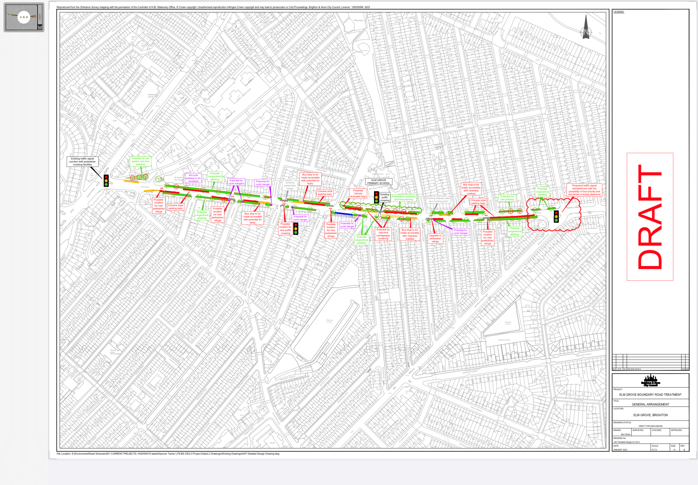
A higher resolution pdf of the plan can be downloaded HERE
Proposal summary
Greening: The proposals look for opportunities for greening throughout. For Elm Grove in particular, opportunities for Sustainable Urban Drainage are helpful – the provision of raingardens as well as other planting will help reduce the impact of rainwater runoff and flooding downhill. The triangle of space behind the bus stop at the bottom of Elm Grove could form a sustainable drainage site.
Bus stops: Throughout the scheme we will look to improve bus stops for accessibility, amending the kerb line to provide level access
Crossing points: The aim is to provide more crossing points to enable safer crossings and support speed reduction, although a balance must be struck between this and maintaining vehicle flow as increased congestion can have an impact on air quality. Crossings points improvements include the potential for a new pedestrian refuges at St Josephs Church at the Howard Road Junction and at Cobden Road, upgrading the existing refuge at Arnold Street, and a new potential refuge at Brading Road. There may also be a new Puffin crossing at the Hampden Road junction, and an upgrade of the existing puffin crossing at Elm Grove School with the addition of coloured carriageway surfacing.
Car parking: The proposal for car parking looks at chicane style parking. This helps reduce speed and also provides a wider running lane to help busses pass other vehicles. The overall aim of the scheme is to be parking neutral and the final plans will be reviews by the parking team to ensure that and reduction in parking is avoided or kept to the absolute minimum.
Cycle parking: All of the existing cycle parking will be reviewed – much of it has been put in place to prevent pavement parking and so is not necessarily in the right place for best use. Potential locations for further bike hangars have also been identified.
Vehicle speed: Measures above including the crossings and parking layout will contribute toward speed reduction. A new vehicle activated sign has been put in place downhill and there is potential for a further uphill vehicle activates sign also
Comments summary
Parking:
At Elm Grove school there is currently illegal parking around the Puffin with no enforcement – could there be a build out here? Yes – there is potential to reduce the carriageway width here. This will be investigated.
We live on Luther street – love the greening on Luther/EG corner You may need a loading bay where the cycle hanger is planned to stop congestion for flour pot.
A full CPZ is vital. Need to expand parking zones – not enough capacity in zone V at the top of Elm Grove. Top tringle should be in zone S.If parking spaces are lost parking permit numbers need to reduce too. Concern about sufficient parking on Elm grove. Parking zones are outside of the scope of this proposal, but and final scheme will be reviews by the council parking team who will be able to assess and changes. The overall aim of this proposal is to be parking neutral.
Need to ban pavement parking: This has been approved by committee and shall be consulted on separately
Crossings:
Why are different types of crossing proposed? Crossing type depends on vehicle and pedestrian flow and follows a government formula. Hampden Rd meets the criteria for a light controlled crossing, but crossings at the other locations do not. They are shown on the plans as refuges but could instead be build-outs if this was preferred. Cost is also an issue with 5 refuges costing about as much as one push button crossing. Push button crossings do delay traffic and can have negative impact on air quality
Vehicle speed:
Elm Grove traffic speed restrictions – Vehicle Activated Sign (VAS) indicators are really important as vehicle speed is a problem. There is potential for an uphill VAS to be added.
Could section beyond tenantry be reduced to 30 – this increases speeding on Elm Grove? Introduce a physical barrier/narrowing at the top of Elm Grove to stop fast cars from warren Road. Speed limits further up have been considered but are outside the scope of this proposal
Could there be Speed cameras on Elm Grove? Camera provision is maintained by police for enforcing speed limits and is unlikely to by prioritised here
Cycle facilities
No safe cycle routs in scheme, so speed reduction is key. Need more measures for cyclists – priority lights, cycle lanes, cyclist alert signs. More cycle hangers. Make them ‘greener’ more attractive. Aside from cycle parking and speed reduction, there are no cycle specific features in this proposal, however Elm Grove has been identified in the Local Cycling and Walking Infrastructure Plan for a potential uphill cycle track and these proposals will keep that in mind as a future possibility.
Greening:
Like the full greening and more trees. Tall wildflowers and shrubs (Elm Grove)
Access:
Need to flatten out tree roots for access for disabled. More benches on Elm Grove. Lots of guard rail on Elm Grove – quite harsh. Guard rail is being looked at.
Elm Grove/Queens Park Road junction
Proposal: Traffic signal refurbishment with the possibility of bus priority – lights will go green for buses reducing delay – and shortening crossing distances
Comments
Live close to EG/QPR junction – lots of accidents and near risks. Improve safety here asap – quick fix improve road markings & sign in wrong place. Junction works will narrow carriageway and reduce speed and confusion
Two – Queens Park Road to Egremont Place

A higher resolution pdf of this plan is available HERE
Proposal summary
Greening: There is potential for street trees in a number of locations between the Elm Grove junction and the Pepperpot. These would be placed on build outs rather than on the pavement. This would impact on parking at locations, but the aim is not to reduce parking, and there are opportunities to increase parking along Queens Park Road through relocation or redesign of bus stops.
Bus stops: As with Elm Grove we will seek to make all bus stops accessible. There is potential to redesign or relocate some stops to increase parking or improve safe crossing (south of Albion Hill) There is the potential for a bus stop clearway on Egremont Place to better enable buses to pass with reduced delay.
Crossings: As with Elm Grove the proposal is to increase the regularity of crossing points and is looking at using islands or build outs depending upon what is preferred. Articular attention is being given to additional crossing points at St Luke’s Terrace comprising a refuge and build outs recognising its importance as a route to school.
Parking: The only significant change proposed is around the tree planting, which is aimed to be compensated for through redesign/relocation of bus stops
Speed reduction: There is the potential for vehicle activates signs in both directions and additional crossing points will also act to reduce traffic speed. Additional proposals include the addition of central hatching on the wider section of Queens Park Road above Pankhurst Avenue which will give the impression that the carriageway is narrower and encourage slower speed. On the narrower section of Queens Park Road (below Islingword Road) it is proposed that the centre line be removed which is also shown to help reduce speed on narrower streets.
Comments Summary
Parking:
How will you increase or keep the same number of parking spaces on QPR? Not enough room for trees on the pavement – narrow bin obstructions…
On street trees reduces parking. Can we have stats on parking demand and bay reduction? Resident bays are long spans with varying capacity. Consider defined bays with EV charging points/build outs at each end stopping them encroaching on pavement The large m/cycle bay on QPR near Richmond St could include a car space or tree space – poorly used currently
Trees will go where some parking is but aim is for no loss of parking A tree takes up the space of half a car but there is potential to add parking as part of this scheme – mostly reducing bus stop size. Haven’t done the detail on this but this will be done with parking team before decisions made.
Greening:
QPR – Elm Grove to Pankhurst – plant trees on the embankment rather than the road. No loss of parking and deeper root stock. I welcome more street trees – even if it takes out parking spaces.
Tree planting outside Pepperpot – would reduce visibility of local landmark. Is the taxi rank needed on QP Terrace/QPR junction. Space here for cycle hanger/bike share instead of Pepperpot lawn
Why no trees shown on QPR between Downs Terr and Pepperpot? Yes to trees south of Islingword. Trees instead of bins. No reason why trees shouldn’t go here will look at it.
Can we look at using moss instead of trees it is more immediate, takes less space, needs less maintenance and you don’t get bird droppings with it.
Speed reduction:
We need to look at ways of enforcing 20mph on QPR rather than simply calming traffic. We need to keep it obstacle free but there are still people who drive very fast without repercussion. How does adding central hatching etc reduce speed? Adding and removing both work depending on carriageway width. Local evidence shows it works. Buses may well straddle lines – that is OK – buses not the problem private cars are the speeding issue
Access:
Streets are blocked by wheelie bins – dangerous and not suitable for QPR. More regular rubbish collections and communal bins. Junction of Southover & QPR has had no consideration despite being busiest junction.
Pavement surfaces terrible in whole area – a real issue for accessibility
Crossings:
Potential for issues around refuges at road junctions/corners. Sussex St/Richmond St end. Residents parking on west side. People park at the end of residents parking bay rows – if a refuge is there parking either blocks road or parks on pavement. Refuges need bollards to prevent parking on them. Junction of Richmond St QPR dangerous because of parked cars causing poor visibility for traffic emerging from Richmond St. Can the south bound bus stop be moved further up the road? Yes – agree. An issue which needs to be taken on. Talking with bus company about moving the bus stop which might help. Will look at build outs as they improve visibility restrict junction parking and improve pedestrian safety. For legibility want to offer a consistent treatment along the route.
Why no zebras on QPR? We do assessments of crossing requests and look at number of vehicles speed, collision rates, pedestrian crossing volume etc…. there is then an equation which recommends from Govt type of crossing. On QPR push button are already there – tend to keep standard and consistent for legibility
Top of Islingword Road – build out proposal – Drays need to get to constant service and islingword pub– build outs and island may be too tight. New traffic island on QPR near Islingword – cars can currently pass busses – an island would prevent this and cause queues.The post office requires vehicles to park outside for cash delivery.
Crossing at top of Egremont place – feels quite dangerous even though there is an island because of poor visibility on bend, This could be a priority area for improved crossing? Junction refuge at Egremont Rd is really dangerous – first cars come from both directions and pedestrian views are obscured. Need lights? Bend might be a bit tight for a crossing because of forward visibility. Not sure quite how to improve it atm but are looking at it. Vehicle activates sign further down should help as well as removing entre line. It is a tricky junction.
Egremont Gate – could all 4 direction be crossed at once with 4 way controls? Like Oxford Circus – cross any direction & all direction stopping? Don’t know – not been considered before but will raise this with traffic light team and see if it could work.
Air quality:
Pollution is a problem as cars will keep engines running on QPR as ppl go to nursery/pharmacy – pollution a problem and greening would be great. Car idling is a problem and BHCC is working to manage or reduce this. Asking drivers to turn off engine tends to work although this is a problem sometimes. Yes – greening can help. Additional air quality monitoring equipment has been put in around the area at key locations and will be able to provide before and after comparisons for the scheme
Egremont Place general
Egremont place – the majority of residents discussion whatsapp has been Egremont place and concern about extra traffic. Too narrow for buses to pass & parked cars get damaged. Coal holes beneath pavement are also being damaged. Could buses be re-routed to mount pleasant /Freshfield? Could light be put at the top of Egremont – create a ped crossing? One way entry in/out of west drive?
Make Egremont Place single flow by introducing lights on QPR. Re route some buses into Freshfield Road. Re route number 23 along Freshfield Rd and QP Terrace.Egremont Place west side needs a cycle lane for cyclists climbing uphill. Ideally separated and would need all parking to be removed.Need seating for people walking
Displace car traffic from Egremont Place with a bus gate and requiring cars to use Freshfield/Mount pleasant. Upper Park Place is one way north and could see traffic displaced from Egremont making this junction even busier
Bus company opposed to removing Egremont Place bus stop Signalising this junction hasn’t been raised before and will investigate. Costs more and has more maintenance and can interrupt flow. Will raise with signal team Haven’t done the detail yet but trees are good and it is a place where they could go
Other general comments:
Worried about increase in traffic – would like to see traffic reduction on boundary roads built in to the scheme targets and success criteria
What is needed is behaviour change to reduce people owning cars – that would reduce traffic, not just slow it down
Blues & Two’s needs challenging – we don’t have an ambulance station on Elm Grove anymore so could we have humps
More measures to encourage walking – street lights, handrails, community spaces

Leave a comment